At the 30th Annual Meeting of the European Association of Archaeologists (EAA), held from August 28 to 31, 2024, at Sapienza University in Rome, we presented a poster on the application of PRISMA pansharpening techniques for enhancing the detection of archaeological traces.
IGARSS paper 2024
International Geoscience and Remote Sensing Symposium 2024 (IGARSS 2024)
Accepted oral presentation to IGARSS 2024
Our contribution, "Pansharpening of PRISMA products for archaeological prospection", has been selected as an Oral presentation for the 2024 Edition of IGARSS in Athens, July 07-12, 2024.
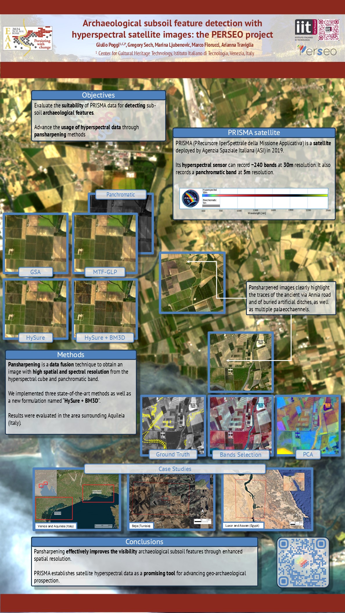
In this contribution, we assessed the usability of pansharpened PRISMA satellite products in geo-archaeological prospection by applying three pan-sharpening methods (GSA, MTFGLP and HySure). We then compared quantitatively and qualitatively the results over the archaeological landscape of Aquileia (Italy)
The area of the ancient Roman city of Aquileia, in Northeastern Italy, is rich in archaeological traces.
Three algorithms were compared in S1, S2, and S3 to enhance the visibility of traces related to the landscape's evolution.
Slider
Super-resolution of Hyperpectral PRISMA images
A pansharpening algorithm is applied to PRISMA images to enhance the spatial resolution of the hyperspectral cube, from 30m to 5m. In the first stage, HySure algorithm was selected.
The pansharpened enhanced image will be measured quantitatively and qualitatively with respect to other state-of-the-art pansharpening algorithms. Moreover, the new image will be tested specifically for the identification of archaeological sub-soli features.
Pansharpening process near the city of Aquileia, in northern Italy
Selection-of-case-studies
Selection of case studies of interest
PERSEO has identified four geographical areas featuring 5 main contexts in diverse environments. Areas were selected across the Mediterranean region to develop and test the methodologies on different conditions, to generalize the outcomes of the project and to extend their applicability to different case studies and user scenarios. Sites were selected, analyzed and described according to the following parameters:
- Geomorphological background
- Land Use management
- Archaeological features
- Accessibility for ground-truthing
1) Aquileia coastal plain (Italy)
The area includes the suburban and rural area of Roman Aquileia: traces of buried ancient infrastructures (such as roads and land divisions called ‘centuriation’) are abundant and visible in its surroundings, together with the remains of rural villas and settlements. Other features might be detectable in the interface between the agricultural landscapes and the lagoon.
2) Venice costal plain and lagoon (Italy)
The area includes the alluvial and coastal plain by the northern stretch of the Venice lagoon. The area includes the suburban and rural area of the roman city of Altinum: traces of buried ancient infrastructures (such as roads and the land divisions called ‘centuriations’) are abundant and visible in its surroundings, together with remains of rural villas and settlements. Other paleo-environmental features, such as paleochannels, are detectable.
3) Aswan and Luxor (Egypt)
This is one of the archaeological richer areas in Southern Egypt, with world-known sites, and it acts as an interface between the Nile Valley and both the Western and Eastern deserts. It is the setting of a large number of necropolises, temples and sites both in vegetated and desertic terrrain.
4) Beja district (Tunisia)
The area in the North-west of Tunisia includes the roman city of Belalis Major. Traces of buried infrastructures are visible on satellite imagery (roads and centuriations), together with a late roman fortress, churches and other archaeological features.
Case studies
Coastal plain and lagoons near the cities of Venice and Aquileia(Italy)
The area includes the suburban and rural territories of the Roman cities of Aquileia and Altinum, which developed since the 2nd century BC. The vast alluvial and coastal plain is intensely cultivated and it is characterised by numerous traces of palaeochannels and reclaimed lagoonal and swampy areas. Archaeological traces include buried infrastructures, such as roads and land divisions called ‘centuriations’, as well as remains of rural settlements and villas.
Beja district (Tunisia)
The area is part of the governorate of Beja, in the northwest of Tunisia. It includes the Roman cities of Vaga (Beja), Belalis Major, and many settlements and rural centres, spanning from the 4th century AD to the Late Antiquity (8th century AD). Traces of buried infrastructures are visible on satellite imagery (roads and centuriations), together with late Roman fortresses, churches and other archaeological structures. Illicit excavation activities (looting) are also detectable in major archaeological sites.
Luxor and Aswan
This is one of the richer archaeological areas of Southern Egypt, acting as an interface between the Nile Valley and the Western and Eastern deserts. It is the setting of a large number of necropolises, temples and sites in desert terrain. In this case study, PERSEO is going to assess the use of spectral signatures to classify archaeological structures at the pixel level.
Tells in Iraq
Systematic mapping of archaeological settlement mounds (tells) offers valuable insights into the emergence, development, and organisation of early complex human societies. In PERSEO we aim at developing ML automated detection methods to improve the identification of tells using optical hyperspectral images. In addition, we aim to exploit spectral properties to differentiate artificial topographically elevated areas from natural elevations. This mapping serves as a preservation against looting activities and other damages to cultural heritage sites.